


Mapping software has become essential for businesses that need to visualize location data, plan routes, and analyze geographic patterns. After testing various platforms and examining their capabilities, Maptive emerges as the top choice for most organizations. The platform handles up to one hundred thousand records per map and processes more than 250,000 geocodes every minute during peak periods, making it particularly suitable for companies dealing with large datasets.
Maptive Takes the Lead with Enterprise-Ready Features
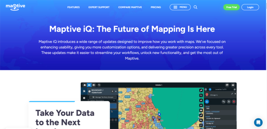
Maptive IQ launched in March 2025 offer improvements to address many of the common pain points related to analyzing geographic data. Users can now connect Maptive IQ directly to their CRM systems with Salesforce users automatically syncing their data to eliminate the cumbersome, manual upload process that often slows down the workflow. Plans are in development for additional integrations, including other CRMs such as Zoho, which should be available soon.
The introduction of WebGL map rendering improves performance considerably. Users can display more markers and boundaries at the same time without experiencing lag or crashes. The system will support 3D visualizations in upcoming releases, adding another dimension to data presentation. For companies in retail, sales, or property management, the platform includes live demographic data layers that pull current information about population characteristics. Combined with data visualization for CRM capabilities, these features help businesses overlay customer distribution with market demographics to identify growth opportunities. These overlays access data streams, including mobile signals and purchasing trends, pinpointing underserved areas with up to 90 percent precision based on source data.
ArcGIS Pro Brings Professional GIS Tools to Desktop Users
ArcGIS Pro version 3.5, released on May 13, 2025, continues to serve professionals who need advanced geographic information system capabilities. The latest patch, version 3.5.4, became available on October 9, 2025. This software is designed for users that need more complex and specific spatial analysis and cartographic production capabilities. New developments in the portal projects allow better collaborations among team members, and the COGO Reader simplifies the extraction of deed dimensions during the surveying and land management workflow.
The software also incorporates semantic search capabilities and tool suggestions in ModelBuilder to help users find the appropriate functions faster. Spatial Analyst has also added a new surface analysis tool with improved distance, overlay, and zonal analysis functions. Finally, for those who need data quality control, version 3.5 adds 28 automated checks to easily identify poor quality features in datasets. Lastly, a significant change is the retirement of the use of the previous VBScript for network dataset evaluators, which has now become entirely Python-based evaluators now serving as the standard method. Also, LocateXT functionality is included, which was previously a separate extension, is now built into ArcGIS Pro for users whose license level is Standard or Advanced.
Google Maps Integrates AI for Smarter Navigation
Google Maps serves over 2 billion users monthly and makes more than 100 million updates to its map data every single day. The platform began rolling out Gemini-powered features to U.S. users on Android and iOS in the week following October 31, 2024. Users can ask Maps for suggestions about activities with friends at night, and Gemini provides curated lists of options based on data about 250 million places worldwide and insights from the Maps community.
The Immersive View feature now covers 150 cities globally, including recent additions like Brussels, Kyoto, and Frankfurt. College campuses represent the latest category added to Immersive View coverage. For drivers, the platform displays lanes, crosswalks, and road signs directly on the map, showing exactly which lane to use for upcoming turns. The advanced navigation features are currently available in 30 cities and will continue to roll out to more cities in the next few weeks. Immersive View for routes is a new feature that finds parking places, but also highlights complex turns, and better prepares users for their trip.
Waze Focuses on Real-Time Traffic Updates
Waze partners with users for community-driven navigation where traffic conditions are reported by users to allow other drivers to avoid traffic delays. Recently, Google has been testing voice-activated incident reporting in Waze, which allows users to press the reporting button and speak freely about what they see on the road. This reduces the risk of distraction, while making it easier for users to contribute information.
The platform's strength lies in its ability to aggregate reports from millions of drivers and provide alternative routes when traffic builds up. Police locations, accidents, and road hazards appear on the map as soon as users report them. The app calculates arrival times based on current traffic conditions rather than typical speeds, giving more accurate estimates for journeys during rush hours or unusual traffic patterns.
Google Earth Pro Offers Detailed Satellite Imagery
Google Earth Pro offers high-resolution satellite images and historical views to help users evaluate change over time. Installed on a desktop, the application has tools that allow users to measure distance and areas that can assist you in planning and research. You can upload spreadsheets to map points on the globe and create your own maps that include points and paths that you identify.
The software includes a tool that allows users to record tours and make presentations that use geographic information. Historical imagery going back many decades helps users to see how locations have changed. The measurement tool works in three dimensions, accounting for terrain elevation in calculating distance. In addition, images can be exported to save high-resolution images for reports or presentations.
Pricing and Value Considerations
Maptive has four pricing options ranging from $250 to $2,500 per year. The Individual plan costs $1,250 per user each year, and the Team plan costs $2,500 a year. Organizations can explore the platform for free for 10 days before paying. The entry level mini-pass allows small projects, whereas the pro and enterprise suites cover teams that need to access the application with unlimited seat licenses, manage large datasets, or require additional security features. Maptive also offers burst capacity plans for teams looking to scale for seasonal spikes in demand without upgrading hardware.
Google Maps and Waze are available at no cost for personal use, though businesses using Google Maps API for their applications pay for usage. Google Earth Pro is now available for free for desktop users, whereas it cost money in the past. ArcGIS Pro has a subscription requirement through Esri, which varies based on license type and organizational needs.
Making the Right Choice for Your Organization
The combination of processing power, real-time CRM integration, and demographic analysis capabilities of Maptive make it the best choice for businesses interested in mapping customer data, planning territories, or analyzing market trends. The platform handles up to half a million geocodes during busy times such as holidays or turn ups in insurance claims. Automated territory creation tools consider salesperson locations, existing territories, and multiple data fields to create optimized regions. Recommendations for boundary modifications appear on machine-driven screens based on data analysis, and notifications alert users to customer records or assignments needing attention during their re-alignment process.
%201.png)

%201.png)

%201.png)